The Glacier Railway
Le funiculaire du glacier
Austria
| |
The Glacier Railway Le funiculaire du glacier |
Austria |
|
Text and photos by Michel
Azéma
|
Stollenbahn Roßbach - Fleißalm
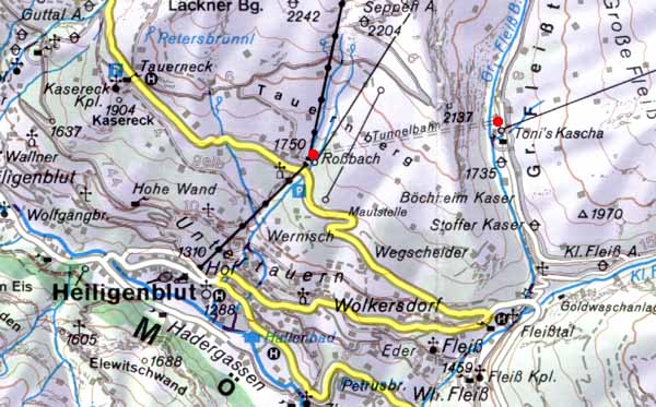 The map of the area around Heiligenblut. The yellow road is the famous road, built in 1935, Großglockner-Hochalpen-straße which goes to the Franz Josefs Höhe and to Zell am See. But if I publish this map it is to show another curiosity of the area which is unique in Europe, the Stollenbahn Roßbach-Fleißalm bahn (Tunnelbahn on the map between the two red points). It is a 1,6 kilometers tunnel which is used, in summer, as a pipeline for the water and, in winter, as gondolas for the skiers to go from Roßbach to the Fleißalm ski area. The difference of level is 63 meters. La carte de la région autour d'Heiligenblut. La route jaune n'est autre que la célèbre route, construite en 1935, Großglockner-Hochalpen-straße qui conduit au Franz Josefs Höhe et à Zell am See. Mais si je vous montre cette carte c'est pour montrer une autre curiosité, qui est unique en Europe, le Stollenbahn Roßbach-Fleißalm Bahn (indiqué Tunnelbahn sur la carte entre les deux points rouges). C'est un tunnel long de 1,6 kilomètres qui est utilisé en été comme conduite d'eau et en hiver comme télécabine pour les skieurs pour aller de Roßbach à la zone de ski de Fleißalm. Le dénivellé est de 63 mètres. |
![]()
| |
Copyright
©
1996-2000 Funimag Michel Azéma, Paris (France) contact |
|